Southeastern Oregon Dual Sport Moto 2020 (with GPS route)
We had 4 days of time off and the need for a motorcycle adventure. Our original (last minute) plan was to do an adventure tour loop of Washington’s Olympic Peninsula. In fact, we even went as far as to purchase the 2020 Olympic Mountains Loop GPS Tour from GripTwister. But when the materials didn’t show up in time (our mistake for not planning ahead, though its unfortunate they cant be sent digitally) and the weather for the Olympics looked gray and rainy, we flipped a coin (yes we literally flipped a coin) and sought out the dry desert emptiness and high alpine landscapes of Southeastern Oregon.

Summary – TL:DR
We did a 4 day big bike motorcycle adventure tour of Southeastern Oregon. Bikes were a 2017 Honda Africa Twin and 2018 Kawasaki Versys X 300.
- Day 1: Hood River to Crystal Crane Hot Springs via Condon, Fossil, and John Day, Oregon. Camped at the hot springs ($30).
- Day 2: Crystal Crane Hot Springs, Pillars of Rome, Chalk Basin, Alvord Hot Springs and the Alvord Desert. Camped on the desert playa (free, $10/vehicle to access playa via Alvord Hot Springs road).
- Day 3: Fields, Oregon milkshakes, Steens Summit, Kiger Gorge, and the Hart Mountain Antelope Refuge. Camped at Hart Mountain Hot Springs campground (free).
- Day 4: Antelope sightings, flat tires, the super helpful folks at Mile-Hi Tire and Service, forest fire detours, sunsets and home via Plush, Lakeview, Summer Lake, La Pine, and Maupin, Oregon.
We made an adventure documentary style video of our trip, available on the Points Unknown YouTube Channel (new!).

GPS routes are available below:
DISCLAIMER: Routes are for reference only and may change without notice. They are a record of our trip and do not serve as a recommendation or endorsement. Always check the weather, road conditions, and ride within your skill level.
Trip Report
Our initial route planning was somewhat nebulous – our goal was to quickly get from our home in hood river down near Burns, Oregon and then explore the nearby dry lakes and mountain regions, including the Alvord Desert and Steens mountain range. But as we set out on our first day, a rough plan for the next three days started to take shape.
On the first day we took to the pavement to cover the nearly 300 miles from hood river to Burns, Oregon. We took the more scenic route through Condon, Fossil, and John Day, Oregon. This was mostly just a grind to get down into Southeastern Oregon. Of course we didn’t get the earliest start, given we had to pack and run a few errands in the morning, so when we did hit the road we really just needed to cover some distance.
We had read that Crystal Crane Hot Springs, just 20 miles east of burns, was a not to be missed destination. So on the way down (somewhere near John Day) we gave them a call to see if we could book a site. As many of you know, COVID-19 has lead to a huge influx of folks camping and seeking out “off the beaten path destinations.” As it was, the hot springs normal campsites (as we learned, the ones with picnic tables) were not available. However, they were able to accommodate us in one of their overflow camping spots (no picnic table). The folks at the hot springs were really friendly – there is a fantastic almost ‘summer camp’ type vibe to the place, with their community kitchen, bathrooms, showers, etc. And even thought he place was pretty full with overnight guests, there were only 4 other guests in the large man-made pool (which is very well done) during our twilight soak.


On the next day, we headed out from Crane Hot Springs towards Rome, Oregon. A few internet articles pointed us to the Chalk Basin Overlook a geological phenomenon with views of the Owyhee canyon about 25 miles north of Rome Station. The rough access road they described sounded like a fun adventure. The road was actually not too bad, but I certainly wouldn’t have wanted to do it in a low clearance vehicle, or anytime near when it had rained. There were some pretty rutted spots that I can only imagine would be completely impassible after a rainstorm. The road wound its way through the open ranch land to some pretty nice views of the Chalk Basin and some distant views of the Owyhee Canyon – but I am not sure that its really worth the trip/hype if you’re not just in it for the ride out there and back. In one article we read, they described the views as a ‘mini painted hills’ (referring to these painted hills, east of Prineville, Oregon). Those painted hills are spectacular, really mind blowing. The Chalk Basin was really cool, but not on that same level (IMHO).
On the way out to the Chalk basin we passed by the Pillars of Rome, but didn’t really stop and take them in. So on the way back we spent some time considering that geologic phenomenon. Now those pillars are really amazing and definitely worth the quick jaunt of the highway outside of Rome, Oregon. Then back to the pavement to fuel up at Rome Station and get a cold beverage (it was HOT in the desert).


From Rome, we partially retraced our track to the turn off towards field Oregon. We had expected this road to be mostly gravel, but the first several miles were actually paved. When it did turn to gravel the first 10 or so miles were fast and fun. But then something changed. It must have been recently bladed and graded, with a lot of new gravel added because the road turned somewhat treacherous with deep gravel that really wanted to pull the bikes around. So our speeds dropped from over 50 MPH down to less than 30 MPH. But we made it safely to Alvord Hot Springs.
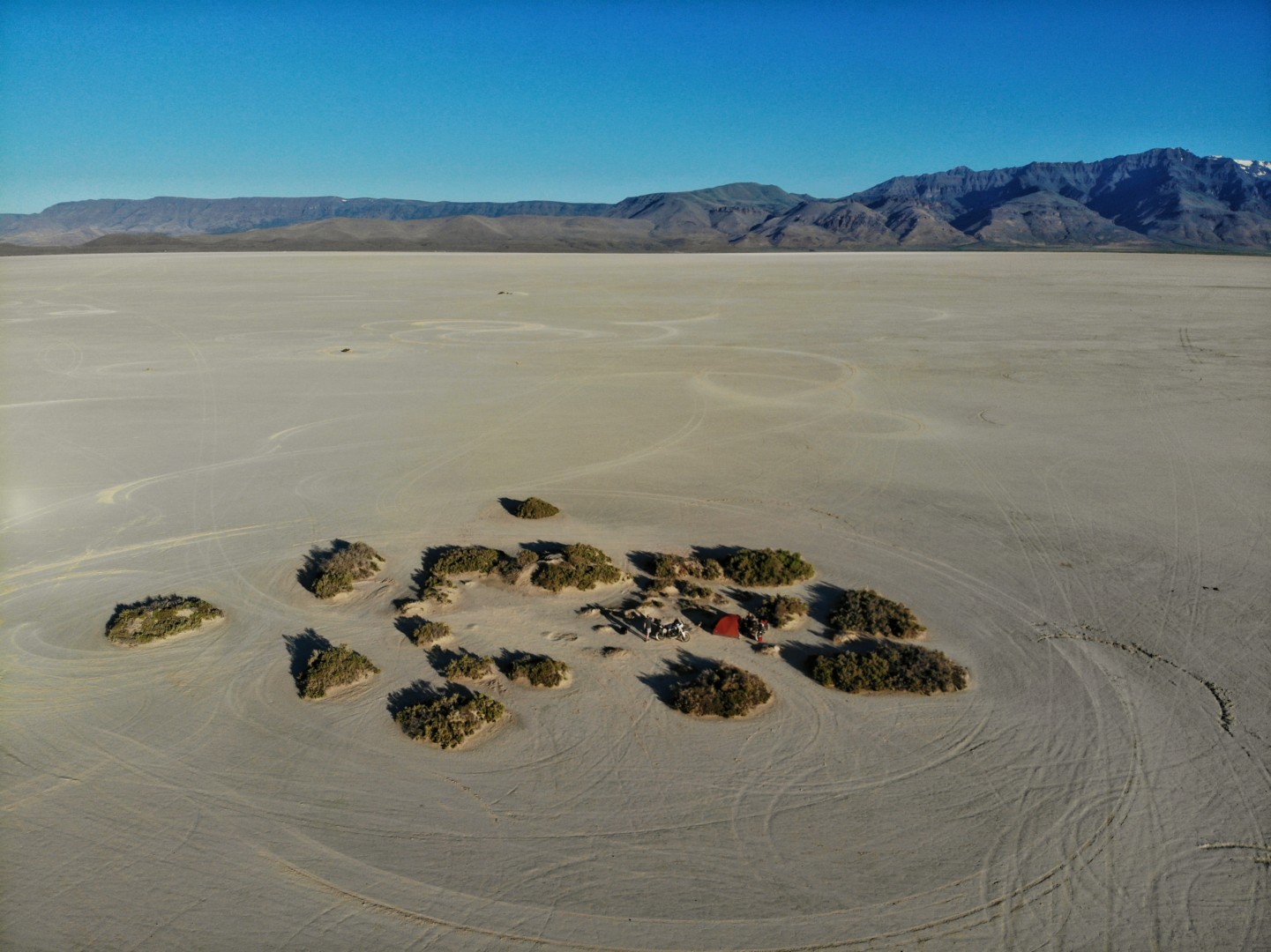
Since we were eager to get out onto the Alvord Desert Playa, we skipped the soak in the hot springs there (hot springs aren’t really aren’t a thing we crave) but did pay the Alvord Hot Springs folks to use there road. Apparently, there are other ways to get down to the playa, but these might be through private land, really rough sandy roads, or not ideal. Whatever the case, we took the easy way and paid the nice folks at the Alvord Hot Springs $10/vehicle ($20 total) to use their road to efficiently get us down onto the desert.
Riding around on the Alvord Desert playa was amazing. Super fun. At roughly 12 miles long and 7 miles wide, it really is as simple as picking a direction (any direction) and rolling on the throttle. After scooting around out there for a bit we headed to the east side of the dry lake bed and found a nice little island of scrub brush to camp behind. The folks at the Alvord Hot Springs had suggested to pick a side, rather than camp in the middle of the desert, to avoid being run over by some joy rider. While there weren’t a lot of people on the desert floor, it seemed like a risk worth avoiding. They also talked about some strategies for getting out of the wind – and when the wind kicked up in the early evening I understood why. In hindsight, given that the wind blew from west to east, it may have been better to be on the west side. But who knows. As it was the wind kicked up big clouds of dust that periodically blew over our tent and all our stuff. So perhaps the other side would have been better? but… no idea.


Starting off day 3, with all of our gear thoroughly covered in Alvord Desert playa, we packed up our tent and headed towards the Steens mountains. But we couldn’t resist one more tour around the empty desert. We had heard that the milkshakes in Fields, Oregon were “world famous” so we skipped breakfast and made our way into Fields right around 8am opening time. The hype was real, the milkshakes were incredible (and gigantic) and we talked to some locals to get a lot of interesting history and information about the area (while safely social distancing sitting outside). Refueled (both the bikes and ourselves) we headed towards the Steens Mountains.
Our new local expert friend recommended doing the Steens Mountain Loop road from south to north, as that offered the best views and better progression into the mountains. We were planning on doing it that way anyway, but it was good for confirmation. And I am glad we did, because the views were really amazing going that direction and it was also nice to be going up the really steep gravel switchbacks in the area some locals call “the roostercomb” rather than coming down it. The Steens Mountain Loop road was unreal – the views from up there really blew me away. Just incredible. Especially to go from the desert to the high alpine in such a short time. Really, breathtaking (quite literally going from 4,000 feet on the Alvord to just under 10,000 feet elevation – the highest road in Oregon?).


After taking in all the incredible vistas on the Steens Mountain Loop road, we headed down into Frenchglen for fuel and food. It being mid afternoon we were a little hesitant to head off across the desert towards the Hart Mountain National Antelope Refuge, just because of the heat. But the folks at the Frenchglen Mercantile were encouraging (“its a fantastic gravel road – you can do 60+ the whole way”) so we hydrated, bucked up and headed out. The road was pretty fantastic, winding through the desert scrub, although it did get a bit wash-boarded once you transitioned onto the refuge land.
The refuge headquarters was all closed up due to COVID, so we continued 4 miles on to the Hart Mountain Hot Springs. Everything we read indicated this was a very lightly used campground and hot springs, but arriving there later afternoon on a Friday we found we were lucky to get a campsite (out of the 25 or so sites, there were only 2 left, and the second one was not so great). As mentioned before, I think COVID is getting more people outside and camping than ever before. But the area around the Hart Mountain Hot Springs is a beautiful aspen oasis in the desert. It was pretty wild to go from desert scrub and sage brush to the shade of tall aspens. Camping there for the night was quite pleasant.


On our last day we headed out from Hart Mountain Hot Springs, back towards the refuge headquarters. Just past the headquarters we finally got our antelope sighting. It was great to see the animals sprint through the desert. Coming over the ridge into Lake County was also incredible – I guess I never really realized how many lakes there were. And coming out of the desert they were a welcome site. Just after coming down from the Hart Mountains the road turned paved. And not more than a mile after that, Beth got a nail in her rear tire.
Us having tubed type tires in our bikes, we pulled over and did the full ordeal of getting the wheel off, tire off, and replacing the tube. Luckily it was still pretty early in the day, so wasn’t too hot, but the mosquitoes where we pulled off were pretty bad. It was worth the extra few minutes to put on a long sleeve shirt and mosquito head-net, to avoid going too crazy. As is typical, we were only carrying larger side tubes for the front tires, and the nail had fairly well shredded the tube, making it a challenge to patch with our small patch kit. So we did as recommended by others and stuffed the 19″ tube in the 17″ rear wheel. This did not look as robust as I was hoping (pushing the tube back into the wheel it appeared to be folded over on itself). But however it worked out once under pressure, it seemed to hold up just fine.
I was a bit surprised as we were pulled over on the side of the road with the wheel off the bike and tire irons in hand that no one stopped to check on us. There was no cell service and the nearest town (Plush) was about 10 or 15 miles away. In the 45 minutes or so it took to change the tube we were passed by perhaps 6 or 8 vehicles, but none asked if we needed anything or even if they could call for a tow truck or something once they got to town/cell service. Which I thought was curious. But no matter, we got the spare tube in and were back on our way.


Services in Plush, Oregon are pretty sparse. The Hart Mountain Store has a gas station and basic essentials, but nothing that could help us with a more robust fix. But we did talk to some folks that recommended the tire service place in Lakeview, Oregon – “next to the chevron [actually Shell] as you come into town”. So we carefully made our way the 40 or so miles to Lakeview. Called around a bit to find the right tire place and were very pleased with the service we received from Mile Hi Tire & Service. The folks there were super friendly and they did a beautiful job patching our 17″ tube (3 patches in all – 2 from the nail, and 1 from where I pinched it putting the tire back on the first time. AKKKKKK! always use the Baja No Pinch tool!!!).
Back on the road near lunch time we found ourselves at the Pioneer Saloon in Paisley, Oregon for a much needed burger (seated at the nice picnic tables outside). From there we put on the pavement miles, up through Summer “Lake”, La Pine, Bend and Madras. In Madras we found out that a forest fire had closed highway 26 and so our usual route home over mount hood and highway 35 was a no go. So we detoured at Madras on highway 97 and then 197 through Maupin and The Dalles. Made it home just before 10:30pm.

All in all a great 4 day adventure. In total, just under 1,100 miles. Mileage wise, probably less than 20% or less dirt/gravel, but time wise it may have been closer to 50/50 (we are not as fast as some of you). Fun times.


Great ride report and thanks for posting the GPX! I’m in Portland and have been thinking of riding out to the Alvord.